Mount Longonot National Park is a National Park in the Great Rift Valley, Nakuru County, Kenya. The park's signature experience is the strenuous day-hike up the steep ravines of the dormant stratovolcano to trek the forested crater rim, which offers panoramic views across the caldera and Lake Naivasha.
Overview
Name
Mount Longonot National Park
Type
Mountain
Town
Mai Mahiu
County
Nakuru
Country
Kenya
Key Facts about Mount Longonot Kenya
Attribute Category
Specific Detail
Location Coordinates
Approximately 0.915° S, 36.455° E
Governance/Management
Kenya Wildlife Service (KWS)
Total Area
52 km² (20 sq mi)
Entry Fees (2024)
Non-Resident: USD 30 (Adult), USD 20 (Child) East African Resident/Citizen: KES 300 (Adult), KES 250 (Child)
Primary Attraction
Hiking the stratovolcano to its crater rim and forested caldera.
Best Time to Visit
During the dry seasons: January to March and July to October.
Geological Formation and Volcanic History of Mt. Longonot
Mount Longonot functions as a stratovolcano within the Great Rift Valley, distinct from the shield volcanoes found in neighbouring regions. T
he mountain’s current structure is the result of plinian eruptions, creating a caldera that measures 8 x 12 kilometres. Unlike the older, eroded craters of the Aberdares, Longonot retains a defined circular rim and a precipitous drop to the crater floor.
The geological signature of the park is defined by trachytic lava flows and agglomerates. A key feature of Longonot is the presence of active fumaroles (steam vents) located along the rim and crater floor, indicating the magma chamber beneath remains active.
Historical records place the last significant eruption in the 1860s, evidenced by the fresh lava flows on the northern flank.
Hiking and Trekking Trails
The hiking experience at Mount Longonot is categorised into two distinct segments: the ascent to the rim and the rim circumnavigation. The trail presents a higher gradient challenge compared to the flat trekking routes of Hell’s Gate National Park.
The Ascent (Gate to Rim)
The primary trail begins at the park gate (2,150 metres above sea level) and ascends to the crater rim (2,560 metres). The path is approximately 3.1 kilometres long and involves navigating loose volcanic gravel and steep gullies known as 'mwekas'.
The Rim Circumnavigation
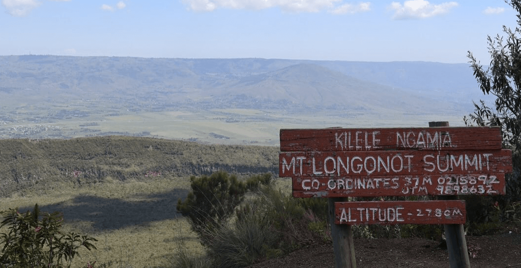
After reaching the rim, hikers can complete a 7.2-kilometre loop encircling the caldera. This section leads to the summit, Kilelwa, at 2,776 metres. The terrain here varies significantly:
Western Rim: Characterised by steep inclines and narrow paths with significant drops on either side.
Summit Section: Requires scrambling over rock faces; this provides panoramic views of Lake Naivasha.
Descent to Crater Floor: This is a restricted and technically demanding route, requiring KWS ranger escort due to the density of Buffalo populations.
Wildlife Found at Mt. Longonot
The ecological distribution within Mount Longonot National Park is stratified by altitude. The lower savannah scrub hosts herbivores common to the Naivasha ecosystem. The crater floor acts as a closed-canopy biosphere.
Common sightings on the lower slopes include:
Plains Zebra (Equus quagga): Found grazing on the peripheral grasslands.
Thomson’s Gazelle (Eudorcas thomsonii): Frequent the open scrub near the main gate.
Coke’s Hartebeest: Often sighted on the protected northern slopes.
Gap Analysis: Unlike parks such as Nairobi National Park, where predators are a primary draw, Longonot’s large predators are elusive. Leopards (Panthera pardus) inhabit the crater forest but are rarely seen during daylight hours.
The primary megafauna threat to hikers is the African Buffalo, particularly solitary bulls encountered in the bushland near the crater rim.
Flora and Fauna of the Park
The park exhibits a distinct separation of floral zones. The exterior slopes are dominated by fire-resistant scrub. The crater interior supports a dense, humid forest not found in the surrounding semi-arid landscape.
Vegetation Zones:
Leleleshwa (Tarchonanthus camphoratus): Dominates the lower slopes; the leaves emit a camphor scent when crushed.
Whistling Thorn Acacia (Vachellia drepanolobium): Prevalent at the base, hosting symbiotic cocktail ants.
Crater Forest: A unique micro-ecosystem containing croton and cedar species that thrive on the geothermal steam and trapped moisture within the caldera walls.
The avian population includes raptors that use the thermal updrafts generated by the volcanic structure. Key species include the Verreaux’s Eagle, known for hunting Hyraxes on the rocky outcrops, and the Lammergeier (Bearded Vulture), occasionally spotted soaring over the rift.
Things to Do and Activities at Mount Longonot
Beyond the primary hike, the park offers specific activities that capitalise on its geological features. Unlike nearby Mount Suswa, vehicular access to the rim is impossible. All activities are foot-based.
Crater Floor Exploration: This requires prior arrangement with the warden. The activity involves a steep descent into the forested floor to view geothermal vents up close.
Geothermal Steam Bathing: Hikers can locate active steam vents along the rim. The steam is hot enough to be palpable, demonstrating the volcano's dormancy rather than extinction. These are not commercial spas.
Rift Valley Observation: The summit provides a triangulated viewpoint encompassing Lake Naivasha to the north, the Aberdare Ranges to the east, and the Mau Escarpment to the west.
Photography Opportunities
The visual characteristics of Mount Longonot are defined by contrast: the arid, dusty trails versus the lush green crater floor. Photographers should focus on the following high-value compositions:
The Caldera Shot: Best captured with a wide-angle lens (16-24mm) from the northern rim to encompass the entire circular depression.
Macro Flora: The Aloe volkensii and other succulents growing in the volcanic rock provide distinct textures.
Atmospheric Perspectives: Early morning climbs (06:00 - 08:00) allow for capturing the mist rising from the crater floor, mixing with geothermal steam.
Mount Longonot National Park Entry Fees and Costs
All fees for Mount Longonot National Park are managed by the Kenya Wildlife Service (KWS). KWS operates a cashless payment system at the park gate. You will need to pay using M-Pesa (a mobile money service) or a credit/debit card. Prices are tiered based on residency status and are valid for a 24-hour period.
Park Entry Fees (Per 24 Hours)
These are the standard conservation fees for a single entry to the park. Always confirm the latest rates on the official KWS website before your visit, as they can be subject to change.
Category
Non-Resident
East African Citizen / Kenyan Resident
Adult
USD $30
KSh 300
Child / Student*
USD $20
KSh 250
*Student rates require a valid student ID and are typically for individuals up to 23 years of age. Child rates apply to persons aged 3 to 17.
Other Potential Costs
Vehicle Entry Fee: A separate fee is charged for vehicles entering the park, depending on the size (e.g., less than 6 seats, 6-12 seats). This is typically between KSh 300 and KSh 1,000.
Guide Fee: Hiring a local guide at the park gate is not mandatory. However, it is highly recommended for safety and a more enriching experience. You should agree on a fee before starting the hike.
Camping Fees: If you plan to stay overnight at the park's campsite, an additional camping fee per person, per night, will apply.
Logistics for Getting to Mount Longonot
Mount Longonot is in a strategic location in the Great Rift Valley. This makes it an accessible day trip from Nairobi. The journey itself offers spectacular views as you descend into the valley floor.
By Road (Private Vehicle or Taxi)
Route: The primary route is via the main Nairobi-Nakuru Highway (A104). You will drive past Limuru and descend the Rift Valley escarpment. At the town of Mai Mahiu, you will turn right onto the Old Naivasha Road (B3). The park entrance is well-signposted a few kilometres down this road.
Distance: Approximately 90 kilometres from Nairobi's city centre.
Time: The drive typically takes between 1.5 to 2.5 hours, heavily dependent on traffic leaving Nairobi. An early start is advised to avoid congestion.
By Public Transport (Matatu)
For the budget-conscious traveller, using Kenya's public transport system is a viable option. From Nairobi's city centre (around the River Road area), board a matatu (shared minibus) heading towards Naivasha. Inform the conductor that you wish to alight at the Longonot town turn-off. From this junction, you will need to hire a boda-boda (motorcycle taxi) for the final 5-kilometre journey to the park gate.
By Train (SGR)
The Standard Gauge Railway (SGR) provides a modern alternative. You can book a ticket on the Madaraka Express from Nairobi to the Mai Mahiu station. From the station, you will need to have a pre-arranged taxi or ride-hailing service to take you on the final leg of the journey to the park, which is approximately a 20-30 minute drive.
Accommodation Options for Visitors
Your choice of accommodation will largely depend on your desired level of comfort and proximity to the park. Options can be divided into staying inside the park for a rustic experience or outside the park for more comfort and variety.
Inside the Park: Camping
For those seeking an authentic bush experience, the only option inside the park is public camping. KWS operates the Olongonot Campsite near the main gate.
What to Expect: This is a basic campsite offering a true wilderness feel. Facilities are minimal, typically including shared toilets and running water.
What to Bring: You must be entirely self-sufficient. This includes your own tent, sleeping bags, cooking equipment, food, and drinking water.
Outside the Park: Naivasha and Surrounds
The vast majority of visitors opt to stay in or around the nearby town of Naivasha, which is a major tourist hub just a 20-30 minute drive from the park gate. This area provides a wide spectrum of accommodation choices.
Luxury Lodges & Hotels: These establishments are located primarily around Lake Naivasha and offer premium comfort, swimming pools, fine dining, and stunning lake views. They are perfect for a relaxing stay after a strenuous hike.
Mid-Range Hotels & Guesthouses: Found both along the Moi South Lake Road and in Naivasha town itself, these offer comfortable rooms, good amenities, and excellent value for money. Many cater specifically to families and groups.
Budget & Backpacker Options: Naivasha town has numerous budget-friendly guesthouses, hostels, and campsites that are ideal for travellers on a tighter budget. They provide basic, clean, and secure lodging.
Mount Longonot National Park weather
The best times to visit Mount Longonot for hiking and panoramic views are during the extended dry season from June to October, and the brief warmer dry spell in January and February. These periods offer minimal rainfall, clearer skies, and excellent visibility into the caldera and across the Rift Valley.